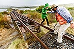
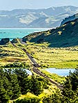
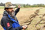
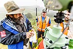
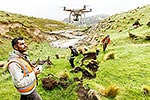
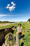
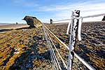
Earthquake fieldwork. GNS earthquake scientists Russ Van Dissen and Pilar Villamor mapping and characterising the 9 metre Kekerengu Fault rupture at a fence distortion. Tirohanga Stream. Kaikoura M7.8 earthquake, Tirohanga, Kekerengu, Kaikoura District, Canterbury Region, New Zealand (NZ), stock photo.
These images are protected by copyright, but we license them to suit your needs. Click
'quick quote' to learn more...
Earthquake fieldwork. GNS earthquake scientists Russ Van Dissen and Pilar Villamor mapping and characterising the 9 metre Kekerengu Fault rupture at a fence distortion. Tirohanga Stream. Kaikoura M7.8 earthquake, Tirohanga, Kekerengu, Kaikoura District, Canterbury Region, New Zealand (NZ) Stock Photo
Earthquake fieldwork. GNS earthquake scientists Russ Van Dissen and Pilar Villamor mapping and characterising the 9 metre Kekerengu Fault rupture at a fence distortion. Tirohanga Stream. Kaikoura M7.8 earthquake, Tirohanga, Kekerengu, Kaikoura District, Canterbury Region, New Zealand (NZ)
 stock photo.")


")