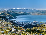
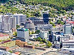
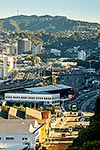
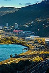
Kaiwharawhara aerial view over Wadestown, Te Kainga, Khandallah and Ngauranga. Belmont Hills and Tararua Ranges beyond. Harbour side faultline visible, Kaiwharawhara, Wellington City District, Wellington Region, New Zealand (NZ), stock photo.
These images are protected by copyright, but we license them to suit your needs. Click
'quick quote' to learn more...
Kaiwharawhara aerial view over Wadestown, Te Kainga, Khandallah and Ngauranga. Belmont Hills and Tararua Ranges beyond. Harbour side faultline visible, Kaiwharawhara, Wellington City District, Wellington Region, New Zealand (NZ) Stock Photo
Kaiwharawhara aerial view over Wadestown, Te Kainga, Khandallah and Ngauranga. Belmont Hills and Tararua Ranges beyond. Harbour side faultline visible, Kaiwharawhara, Wellington City District, Wellington Region, New Zealand (NZ)
 stock photo.")


")